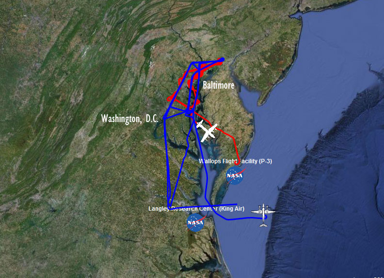
The instruments aboard the King Air UC-12 and the P3-B will help scientists at NASA, the Maryland Department of the Environment, and research universities across the country learn how to better measure air quality. (NASA)
Breathe easy, Maryland. Or easier, at least.
That’s the idea behind NASA research planes that will fly over the Baltimore-Washington region and northeast Maryland this summer. The project, known as DISCOVER-AQ, will measure ozone gases, harmful particles and other chemicals in the air to get a better picture of the makeup of what goes in our lungs every day.
Air quality is measured by Earth-observing satellites, but these can’t distinguish between pollution sitting high in the atmosphere and what’s going on at ground level. During the summer, NASA will use low-flying planes to test the air over traffic corridors and air quality monitoring stations in Maryland.
“Just look up for us,” said Jim Crawford, the principal investigator for the NASA mission. Crawford said the planes will fly low enough that you might see them while driving. “Folks have said that the NASA logo is visible. You should be able to see that it’s us.”
In the Air
NASA will measure five air contaminants. “The key is to measure the same thing from multiple perspectives. The things that a satellite can see are: ozone, particulate matter, nitrogen oxide, formaldehyde, and carbon monoxide,” Crawford said.
Ozone is a reactive gas that can irritate the lungs, and adversely affect plants, reducing agricultural productivity.
Particulate matter is small particles of soot that can enter the lungs and make breathing difficult, especially for the very young, the elderly, and asthmatics.
Nitrogen oxide and formaldehyde measurements give clues about how much pollution is coming from vehicles. “When you combust fuel in an engine, you break the nitrogen oxygen up and recombine it into nitrogen oxides. You also break down hydrocarbons, which are in the fuel. Those hydrocarbons lead to formaldehyde,” Crawford said. The NASA planes will measure these chemicals that make up ozone to help identify the emission source.
Other chemicals the planes measure include carbon dioxide, carbon monoxide and methane. “We measure if they scatter, if they absorb, what they are made of chemically, to try to understand not just how much is out there but where it’s coming from and how it gets moved around,” Crawford said.
Winged Wonders
Two planes carrying 11 instruments total work together on DISCOVER-AQ, piloted by airmen from the NASA Wallops Flight Facility and the NASA Langley Research Center.
The smaller of the two, the King Air UC-12, will collect data from 26,000 feet, acting somewhat like a satellite. “It does what we call remote sensing,” Crawford said. “It uses a downward-facing laser to look at the particles in the atmosphere. It also uses a spectrometer which looks down and senses the sunlight coming back at it, showing gaseous pollution.”
The P3-B, still a small commuter-type plane, will fly in wide spirals from 15,000 feet down to 1,000 feet off the ground. The instruments on the P3-B stick out of the sides of the aircraft, measuring the air that passes through them during the entire flight. With this data, NASA will be able to map out the vertical distribution of pollution and determine how much is nearer the ground and more harmful to breathe.
Fourteen Flights
The P3-B will pass directly over I-95 on a stretch between the Washington Beltway and the Baltimore Beltway, and will also fly over Northeastern Maryland and over I-695 to the west of the Baltimore Beltway.
“The planes will make up to 14 flights over the summer,” said Ken Pickering, project scientist for DISCOVER-AQ, “which will be scheduled to take measurements during a variety of pollution conditions, from very polluted to relatively clean.”
NASA is working with the Maryland Department of the Environment to compare data from the flights with that from six air quality monitoring stations. “Maryland is a region that has traditionally experienced poor air quality,” said Crawford. Over the last 40 years, the Clean Air Act, and Maryland’s own Healthy Air Act have helped to improve that.
“Maryland’s air quality has improved dramatically in recent years,” said Jay Apperson, deputy director of communications for the Maryland Department of the Environment. “Up to 70 percent of the air pollution in Maryland comes from outside of Maryland,” he said, with most of the traveling pollutants coming from the south and Midwest.
The data collected from the research flights will not only help determine the air quality and sources of pollution near the ground, but will help fill in the gaps of data between ground monitoring stations, and will inform designs of new satellites to better measure air quality in the future.
